
Cycling infrastructure safety is one of the key matters that still needs to be solved when Public Authorities and the entire network of mobility stakeholders want to successfully implement sustainable transport strategies.
This is why the second of Molière’s use cases, LanePatrol, has been focused on maximising the opportunities that Galileo’s geolocation accuracy and reliability can offer to this specific industry issue.
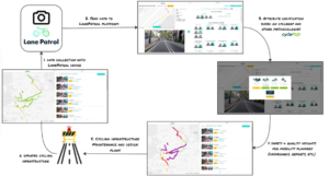
LanePatrol consists of an image-collection device designed by Keita Mobility Factory that was developed to assess and improve cycling infrastructure safety. This device contains a GNSS receiver to be able to geolocate the images with enough accuracy, especially in urban areas where it can be more difficult to obtain accurate positioning.
LanePatrol Device
LanePatrol also leverages the CycleRAP methodology, a comprehensive approach based on an international standard which provides a way to objectively measure and benchmark safety. Putting LanePatrol and CycleRAP together, and using Galileo’s benefits, it is possible to assess cycling infrastructure and score it with a bespoke safety level for sections of approximately 10 metres. This is done through the use of images obtained from a device that collected georeferenced images while mounted on a moving bike.
The CycleRAP methodology helps mapping the areas where there is a higher risk of cycles and light mobility crashes to occur. “The model uses data about the features of a road, street or path to evaluate the risk of accidents for cyclists and light mobility users—irrespective of the type of facility (or whether it is on or off-road) and for all incident types. It can be used anywhere in the world“.
The CycleRAP methodology has proven effective in objectively measuring and benchmarking safety for bicyclists and light mobility users, regardless of the type of facility or location. It analyses four categories of crash types and aggregates the risk value to provide an overall risk score for each route section, with the overall qualitative score determined by the highest risk score among the four categories.
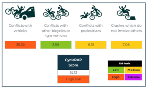 Scoring Example
The chosen areas to trial this use case were the routes that connect Barcelona (Spain) to two adjacent cities, Castelldefels and Badalona, and other towns along the routes: Esplugues del Llobregat, Cornella del Llobregat, Sant Boi del LLobregat, Viladecans and Gava summing a total of around 400k inhabitants, covering over 75kms.
The insights generated through LanePatrol and CycleRAP have revealed critical safety information about the analysed cycling routes. A report with the analysis, findings and conclusions has been delivered as part of Moliere’s output and shared with relevant stakeholders in the public and private sector. The scoring from the CycleRAP methodology will also be shared in the shape of a colour-coded layer on map services, including Moliere’s MaaS app, LanePatrol, and the Mobility Data Space from Germany
The insights gathered from these assessments are valuable for urban planners, city authorities, and policymakers to prioritise safety measures and design more cyclist-friendly infrastructure. By focusing on the identified high-risk areas and implementing appropriate safety measures, it is possible to improve overall road safety for bicyclists and light mobility users.
LanePatrol’s use of geolocated images and the CycleRAP methodology in Molière demonstrates the potential of technology and data-driven approaches to make urban cycling safer and more appealing for residents and visitors alike.
As cities strive to promote sustainable and active modes of transportation, solutions like LanePatrol play a crucial role in building safer, more inclusive, and sustainable urban mobility networks. The success of LanePatrol and CycleRAP in this use case underscores their relevance and potential in addressing critical challenges in urban mobility, paving the way for safer and more accessible transportation systems.
The future of this solution is to continue leveraging Galileo and other remote sensor services, for example EU-DEM v1.0, a digital surface model (DSM) to automatise part of the CycleRAP assessment on LanePatrol. Furthermore, after a positive validation of the LanePatrol service, there are functionalities in the pipeline such as creating automated maintenance and investment plans for local and regional stakeholders to improve the cycling infrastructure safety.